Edro III Shipwreck
Tucked along the rugged coastline of western Cyprus, near the village of Peyia and the Sea Caves area, the Edro III shipwreck rests like a rusted sentinel watching over the Mediterranean. What began as an unexpected maritime incident has evolved into one of Paphos’s most iconic and intriguing landmarks—drawing photographers, wanderers, and dreamers to its windswept perch.
The Fateful Night
On the stormy night of October 8, 2011, the Edro III, a Sierra Leone–flagged cargo ship, was making its way from Limassol to Rhodes with a load of plasterboard. Battling fierce winds and tumultuous waves, the ship was pushed off course and ran aground on the rocky shoreline near Peyia. Caught between sea and stone, the ship became wedged on the rocks—unable to move forward or back.
Thankfully, in a swift and heroic rescue, all nine crew members were airlifted to safety by helicopter. No injuries were reported, but the ship was left stranded, tilted slightly and wedged permanently into the landscape.
Nature’s Slow Embrace
At over 80 meters in length and weighing more than 2,000 tons, the Edro III is no small presence. Yet despite numerous assessments, experts deemed the ship too large and too precariously positioned to safely remove. Efforts were made to clean the vessel of fuel and pollutants to prevent environmental harm, but the wreck itself was left where it fell.
Over the years, nature began to claim it—waves battering its hull, rust staining its flanks, and sea air corroding its structure. What could have been an eyesore has instead become something far more poetic: a monument to the sea’s power, time’s passage, and the ever-changing relationship between man and nature.
A Photographer’s Dream
Few places in Cyprus are as dramatic or atmospheric as the Edro III shipwreck at sunset. The ship’s skeletal silhouette cuts across the sky as the sun dips below the horizon, painting the waters in gold and crimson. The wreck is especially popular among photographers, influencers, and artists who find inspiration in its eerie stillness and industrial decay.
Even casual visitors are captivated by its presence. The combination of rust, rock, and rolling waves gives the area a cinematic feel—an apocalyptic beauty that’s both haunting and strangely peaceful.
Exploring the Area
The shipwreck sits just off a craggy coastal road not far from Coral Bay and is easily reached by car or even by bicycle. The immediate area is popular for walking, with a rough path leading down to the shoreline where visitors can view the ship from various angles. Climbing onto the wreck is not permitted due to safety concerns, and the structure is considered unstable—but there are plenty of vantage points from the rocks nearby.
Just steps away from the wreck is Oniro by the Sea, a stylish café and bar carved into the cliffside. With chilled drinks, sunset views, and comfortable seating, it’s the perfect place to take in the scene and soak up the mood.
Nearby, the Sea Caves and Avakas Gorge offer additional adventures for hikers, swimmers, and nature lovers. In fact, many visitors make the Edro III part of a day-long exploration of western Cyprus’s wild coastline.
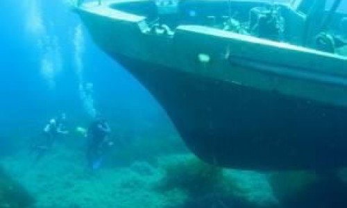
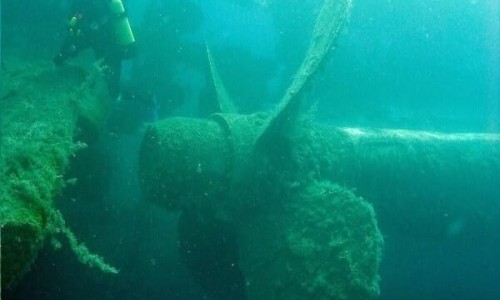
Underwater Secrets
While the wreck itself isn’t diveable due to its shallow and rocky resting place, the surrounding waters are rich with marine life. Local divers and snorkelers often explore nearby reefs and rocky outcrops, where they encounter octopus, colorful fish, and the occasional stingray or moray eel. The area is also popular with paddleboarders and kayakers, offering a unique water-level view of the ship from offshore.
A Living Relic
The Edro III is not just a shipwreck; it’s a living story. It speaks to the forces that shape our world—wind, water, and time—and how something abandoned can be transformed into something iconic. For locals, it’s become part of the landscape. For travelers, it’s a curiosity, a photo opportunity, and often an unexpected highlight of their trip to Paphos.
Final Reflections
There’s something quietly profound about standing near the Edro III, listening to the waves crash against its hull, and imagining the night it came to rest here. It's a reminder of how quickly nature can change our course—and how beauty can be found in the unplanned and imperfect.
Whether you're visiting for a quick snapshot, a romantic sunset, or simply to contemplate the sea, the Edro III offers more than just a wreck. It offers a memory, a mood, and a moment suspended in time.