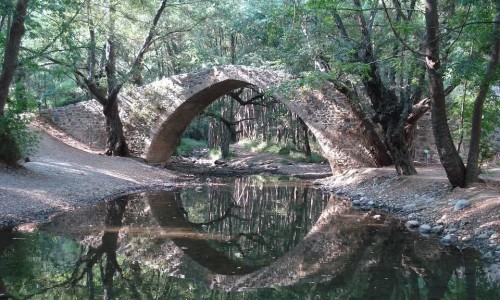
Gefiri tou Roudia (Roudia Venetian Bridge)
Deep within the tranquil embrace of the Paphos Forest lies Gefiri tou Roudia—one of Cyprus’s most enchanting medieval stone bridges. Surrounded by towering pines, leafy plane trees, and gurgling streams, this single-arch bridge feels like something out of a storybook. Though centuries old, it continues to captivate visitors with its understated beauty and atmospheric setting.
A Name Rooted in Nature
The name “Roudia” is believed to come from the roudi bush—Cyprus sumac—which was once abundant in the area. In the past, sumac leaves and bark were used for leather tanning and dye production, making the region economically important during Venetian rule. The bridge likely took its name from the surrounding vegetation that defined the landscape and local livelihood.
History and Architecture
Gefiri tou Roudia dates back to the Venetian period (1489–1571), when the occupying power built a network of stone bridges to support trade and travel across the island’s mountainous interior. This particular bridge served pack animals transporting goods—most notably copper from nearby mines—toward the coastal ports.
The bridge spans roughly 10 meters across a tributary of the Xeros River, with a beautifully proportioned semicircular arch that rises about 5.6 meters above the water. Constructed entirely of local stone, it remains a remarkable example of practical medieval engineering adapted to Cyprus’s rugged terrain.
Though damaged by an earthquake in 1953 and almost demolished during British rule to make way for road improvements, the bridge was eventually restored in the late 1970s. Thanks to that effort, it now stands as one of the best-preserved Venetian bridges on the island.
A Natural Wonderland
Set in a dense forest of pine, oak, and plane trees, the area surrounding Gefiri tou Roudia is a haven for nature lovers. The flowing stream below is crystal clear, and the bridge is often framed by thick greenery, wildflowers, and birdsong. It’s especially beautiful in spring, when the forest bursts into bloom, and again in autumn when the leaves turn to fiery shades of red and gold.
Wildlife thrives here—look out for mouflon tracks, butterflies, frogs, and birds flitting through the canopy.
Hiking the Venetian Bridges Trail
Gefiri tou Roudia is part of the scenic Venetian Bridges Trail, a well-loved hiking route that also features Tzelefos and Elia bridges. These three historic spans are connected by forest tracks and footpaths that weave through some of the most breathtaking and unspoiled terrain in Cyprus.
One popular trail starts at the deserted village of Vretsia, where a gentle 3-kilometer walk leads to the bridge, offering glimpses of abandoned buildings, a ruined watermill, and tranquil riverside views. The full trail, connecting all three bridges, stretches about 17 kilometers and is ideal for a day hike.
A Photographer’s Paradise
For photographers, the bridge is pure magic. Its graceful arch and mossy stones are often mirrored in the waters below, especially after rainfall. The play of light through the trees, combined with the textures of stone and water, makes it a perfect location for landscape and nature photography. Whether captured at dawn with mist rising over the stream or in the golden glow of late afternoon, the bridge never looks the same twice.
Cultural Preservation
Today, Gefiri tou Roudia is considered a cultural treasure—protected as part of Cyprus’s medieval architectural heritage. Its survival reflects a growing appreciation for traditional craftsmanship and the importance of preserving rural landmarks that tell the story of the island’s past.
Timeless and Tranquil
Walking across Gefiri tou Roudia is like stepping back in time. There are no crowds, no ticket booths, no modern distractions—just the sounds of the forest, the whisper of the stream, and the ancient stones underfoot. It’s a reminder of a slower, simpler way of life, where craftsmanship and nature existed in quiet harmony.
Visitor Info
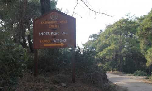
- Getting There: Best accessed from Vretsia or via forestry roads (a 4x4 is recommended if driving deeper into the forest).
- Hiking Difficulty: Easy to moderate, depending on the route.
- When to Visit: Spring and autumn are ideal for hiking and photography.
- What to Bring: Water, sturdy shoes, a camera, and a sense of adventure.
- Facilities: None on-site—pack what you need.
Gefiri tou Roudia is one of those rare places that feels untouched by time. Its quiet beauty and historical resonance make it more than just a bridge—it’s a symbol of Cyprus’s rich and layered past. Whether you're exploring on foot, capturing photos, or simply looking for a peaceful moment in nature, this hidden gem is well worth the journey.