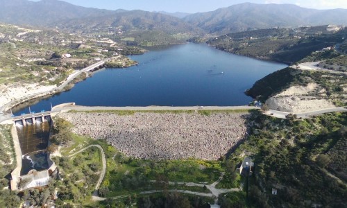
Pera Pedi Dam
Tucked into the peaceful green folds of the Troodos foothills, Per Pedi Dam is one of Cyprus’s quietest and most charming reservoirs—a place where the natural world still takes center stage. Just outside the small village of Per Pedhi (or Per Pedi), this lesser-known destination offers visitors a tranquil retreat surrounded by pine forests, gentle hills, and the soft whisper of flowing water.
Unlike the larger, more commercialized dams scattered across the island, Per Pedi Dam is small, intimate, and rarely crowded. It’s the kind of place you stumble upon during a countryside drive or a nature walk—and once you’ve seen it, you want to return. Here, time slows, the air is fresh, and the landscape unfolds gently in every direction.
A Dam in Harmony With Nature
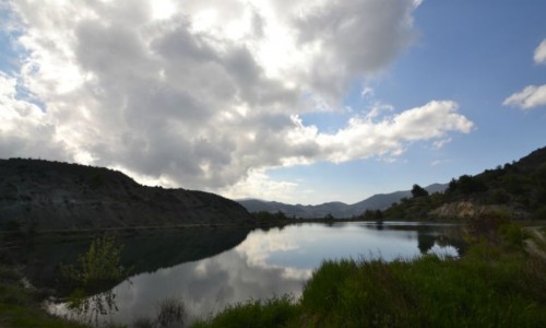
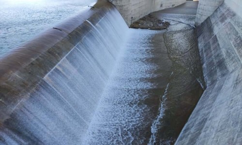
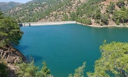
Per Pedi Dam blends seamlessly into its surroundings. Built along the small tributaries of the Kouris River, the dam is modest in scale, collecting mountain runoff and spring water to form a still, shimmering reservoir. The surface of the water reflects the tall pine trees and cypress that line its banks, creating mirror-like scenes perfect for photography or quiet contemplation.
Because of its relatively small size, Per Pedi Dam doesn’t feel engineered or intrusive. There are no high walls or sprawling roads—just a simple structure nestled into the terrain. The water level rises and falls with the seasons, and in the colder months, mist often drifts across the surface in the early morning, giving the place a slightly magical atmosphere.
Walking and Watching: Simple Pleasures
Visitors come to Per Pedi Dam mostly for the simplicity of the setting. There are no kiosks, no viewing platforms, and no built hiking trails—just soft, walkable paths that weave between pine trunks and along the reservoir’s edge. It’s perfect for a slow amble, a quiet picnic, or a spontaneous photography session.
In spring, the area comes alive with wildflowers and birdsong. You may spot herons gliding low across the water, swallows looping overhead, and the occasional kingfisher flashing by in a streak of turquoise. The air smells of pine needles and damp earth, and the silence is so complete that every twig snap or bird call feels amplified.
In autumn and winter, the mood changes. The trees turn darker, the ground softens, and the atmosphere becomes more contemplative. It’s a favorite time for nature lovers, solo walkers, and even amateur painters who set up their easels to capture the muted beauty of Cyprus’s cooler seasons.
A Village Just Above
The nearby village of Per Pedi sits on a slope above the dam, offering charming stone houses, narrow winding lanes, and views that open across the valley. It’s a small village, but it carries a deep sense of history and local identity.
You’ll find old churches with aging frescoes, traditional Cypriot homes with terracotta roofs, and locals tending to gardens filled with fruit trees and flowers. The village is also known for its connection to the Komiakos stream that flows into the dam below, giving life to the vineyards and orchards of the area.
A walk from the village down to the dam is one of the most rewarding ways to experience the landscape. Along the way, you'll pass olive groves, clusters of carob trees, and fields that bloom with color in springtime.
Who Should Visit Per Pedi Dam?
Per Pedi Dam isn’t a tourist hotspot—and that’s exactly why it appeals to a certain kind of traveler. It’s perfect for:
- Nature lovers seeking an uncrowded, forested escape
- Birdwatchers and amateur photographers drawn to reflective water and pine woods
- Hikers and walkers who prefer soft trails and quiet views
- Couples or solo travelers looking for peace and introspection
- Picnic-goers who enjoy rustic surroundings far from city life
It’s also a wonderful stop for anyone driving through the Limassol–Troodos corridor, especially when paired with a visit to nearby villages like Platres, Mandria, or Trimiklini.
Tips for Visiting
- Wear good walking shoes, as the terrain is natural and can be uneven in places.
- Bring your own food and water—there are no facilities at the dam.
- Visit in the morning or late afternoon for the best light and atmosphere.
- Respect the silence—this is a place that thrives on its stillness.
- Combine your visit with a nearby winery, café, or village stroll to make it a full countryside experience.
There are no information boards or signs around the dam, so treat it like a hidden gem. Let yourself discover it slowly, like a local might—with no expectations and plenty of time.
A Place to Breathe
Per Pedi Dam may not make it onto glossy brochures or island-wide itineraries, but that’s precisely its magic. It’s a place where you can sit beneath the trees, watch dragonflies dance across the water, and feel as though you’re the only person in the world.
In an island known for its beaches, ruins, and nightlife, this quiet little dam reminds you that stillness is also a kind of luxury—and that sometimes, the best places are the ones that don't ask for your attention but quietly earn your affection.
Name: | Pera Pedi Dam |
Location: | Limassol District |
Year built: | 1956 |
River: | Krios |
Purpose: | Irrigation |
Type: | Gravity |
Dam category: | Large |
Capacity: | 55.000 m3 |