Mitsero Mine
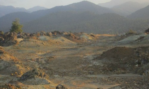
Tucked into the low, rust-red hills of central Cyprus, the Mitsero mine is one of the island’s most evocative industrial heritage sites. For centuries the broader region produced copper and iron sulphides that fed smelters, funded trade, and shaped communities. What remains today is a striking post-industrial landscape—oxidized slopes, angular spoil heaps, flooded pits, and the famous “red lake”—that tells a compact story about geology, modern extraction, and the long afterlife of mines once the machinery falls silent.
Where It Is and Why the Ground Is Red
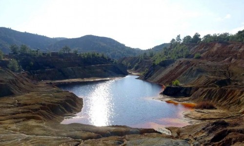
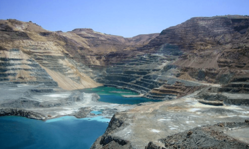
Mitsero lies in the Nicosia District, within the Troodos ophiolite—an upthrust slice of ancient oceanic crust renowned for its volcanogenic massive sulphide (VMS) deposits. These deposits typically carry copper (often as chalcopyrite) alongside pyrite and other sulphides. When exposed after mining, sulphides react with air and water to create acidic runoff. That runoff dissolves iron, which then oxidizes and precipitates as iron hydroxides—painting pools, gullies, and spoil with the reds, oranges, and ochres that make the site visually distinctive. The “red lake” is a flooded open-pit where these reactions are especially intense, giving the water its surreal hue.
Short History of Mining at Mitsero
- Antiquity to Early Modern Period: Cyprus has been synonymous with copper since the Bronze Age, and the terrain around Mitsero bears traces of small-scale ancient workings—hand-dug prospects and shallow adits following oxidized caps of ore.
- Industrial Era (20th Century): Systematic exploitation ramped up with modern surveying, mechanized drilling, and improved haulage. The deposit(s) near Mitsero were exploited for copper and pyrite using a mix of underground stoping and, later, open-pit methods. Rail or truck haulage moved ore to concentrators and ports.
- Late-Century Decline: As grades depleted and global prices fluctuated, the operation became uneconomic. Processing ceased, equipment was dismantled or scavenged, and the pits and underground voids flooded—creating the water bodies and oxidized features visible today.
How the Mine Worked
- Geology & Exploration: Geologists mapped gossans (rusty caps), ran geophysics, and drilled to outline sulphide lenses within altered volcanic rocks.
- Extraction:
- Underground: Shafts and declines accessed ore bodies; miners used drilling-and-blasting to create stopes, leaving pillars or backfilling as needed.
- Open Pit: Where ore was near surface, benches were cut with haul roads winding down to the pit floor.
- Processing: Ore was crushed and ground; flotation separated sulphide minerals into a concentrate shipped for smelting. Waste (tailings) and barren rock were stacked in dumps—features that now define the surface topography.
Life Around the Mine
Mining shaped local livelihoods: shifts, canteens, repair shops, and transport jobs fostered a distinct rhythm and identity. Company investment often brought roads and utilities, while migration for work changed village demographics. As the mine wound down, communities faced the familiar challenge of transitioning to new forms of employment.
Environmental Legacy and the “Red Lake”
Mitsero’s most iconic sight is the rust-colored lake in a flooded pit. The coloration stems from acid mine drainage and dissolved iron. While photogenic, such waters are typically acidic and may contain elevated metals—unsuitable for swimming or contact. Vegetation recolonization varies: hardy shrubs and reeds establish first, followed by a slow return of soils and insects, birds, and reptiles adapted to arid, mineralized ground. The site is a living classroom for mine geochemistry and ecological succession.
Safety note: Do not swim, wade, or let pets drink from the lake or runoff channels. Keep to obvious tracks and watch footing on loose spoil.
What You’ll See Today
- Open Pit Rim & Spoil Heaps: Layered benches and steep talus slopes that glow red at sunrise and sunset.
- Adits and Shafts (Fenced/Closed): Entrances may still be visible—never enter or approach; underground voids are unstable and oxygen-poor.
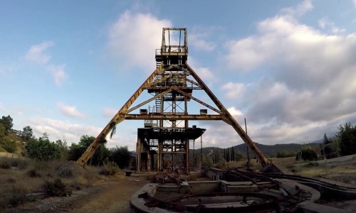
- Old Infrastructure Footprints: Concrete plinths, foundations, and scattered relics hint at crushers, conveyors, or pump stations.
- Runoff Channels: Orange-red rivulets that drain into the lake after winter rains—excellent for understanding oxidation patterns.
Photography Tips
- Light: Aim for early morning or golden hour; iron-rich earth saturates beautifully under low sun.
- Perspective: Contrast industrial geometry (benches, foundations) with natural forms (shrubs, clouds).
- Weather: After rain, the colors pop and small reflective pools appear—bring boots.
- Respect Boundaries: Shoot from safe, designated areas; telephoto lenses help frame details without getting close to hazards.
Visiting Responsibly
- No Swimming or Wading: The water chemistry can be harmful.
- Stay on Tracks: Spoil can collapse; hidden voids exist.
- Leave No Trace: Pack out litter; avoid disturbing any wildlife or plants reclaiming the ground.
- Mind the Seasons: Cyprus summers are hot; carry water and sun protection. In winter, surfaces can be slick.
- Local Consideration: Park considerately, keep noise down, and treat the area as both a natural and cultural site.
Education and Heritage Potential
Mitsero is ideal for school and university field trips covering:
- Ore deposit geology and the Troodos ophiolite
- Mining engineering and landscape transformation
- Environmental geochemistry and remediation
- Industrial archaeology and community history
Interpretive signage, guided walks, and small exhibits could deepen public understanding while keeping visitors safe and impacts low.
Practical Notes
- Access & Time: The site sits within a short drive of major towns in central Cyprus; plan 60–90 minutes to walk the perimeter viewpoints safely.
- Footwear: Sturdy shoes with grip are essential.
- Facilities: Do not expect services on site; stock water and snacks beforehand.
- Safety: Avoid edges, do not enter fenced areas, and supervise children closely.
Frequently Asked Questions
Why is the water red?
Because iron from sulphide minerals dissolves in acidic water and then oxidizes, forming rust-like compounds that color the lake.
Is it safe to visit?
Yes, if you stay on established tracks and keep a sensible distance from pits, edges, and water. Do not enter any underground openings.
Can I swim there?
No. The chemistry can be hazardous to people and animals.
What’s the best time to see it?
Winter and spring bring vivid colors and cooler temperatures. Sunrise and sunset provide the most dramatic light year-round.
Mitsero mine is more than a photogenic red lake. It is a compact, open-air archive of Cyprus’s metallogenic heart, a reminder of how geology, technology, and community intertwine—and a call to care for post-industrial landscapes with both curiosity and caution.